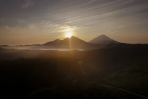
Before Bali became a global tourism hotspot, its southern landscapes were dominated by paddy fields, coconut groves, and tranquil coastlines. That changed dramatically after the 1968 inauguration of Ngurah Rai International Airport, setting the stage for a tourism boom that would reshape the island’s economy and way of life.
Now, for the first time, declassified satellite images from 1965 provide a rare glimpse into Bali before mass tourism took hold.
The high-resolution imagery, captured by the once-secret KH-7 Gambit satellite during a Cold War-era U.S. reconnaissance mission, has been made publicly available on Nusantara Atlas, a digital mapping platform.
The images, boasting a resolution of 0.61–0.91 meters, allow users to zoom in on South Bali with unprecedented detail.
A Rare Window Into the Past
The images, released by The TreeMap, an organization specializing in historical and environmental mapping, offer an interactive way to explore Bali’s past.
Users can enter a Bali address, zoom in up to a 1:1000 scale, and use a time slider to observe the transformation over the past six decades.
While Bali’s rapid development is widely recognized, much of the historical landscape data has remained undocumented.
These newly accessible images change that, allowing researchers, urban planners, and residents to analyze the island’s evolution from rural farmland to a bustling tourism hub.
The satellite imagery from 1965 reveals a vastly different Bali, with much of South Bali—now filled with resorts, villas, and commercial hubs—appearing as expansive rice paddies and untouched coastline. Areas such as Kuta, Seminyak, and Nusa Dua, which are now densely developed tourist centers, were once dominated by agricultural land and open spaces.
A Rare Window Into the Past
Since the 1970s, the pace of development has accelerated. The once-quiet beaches of Kuta became a magnet for international visitors, sparking a wave of hotel and infrastructure projects. Seminyak and Canggu followed suit, with rapid urbanization transforming once-rural landscapes into high-end destinations. Ubud, previously a small artists’ village, expanded into a cultural and wellness retreat.

While tourism has brought economic prosperity, it has also introduced challenges, including environmental strain, traffic congestion, and debates over sustainable development.
These satellite images serve as a visual record of how much has changed—and may provide insight into future planning efforts.
For those eager to explore Bali’s past, the interactive platform on Nusantara Atlas offers a unique opportunity to step back in time. Whether for historical curiosity or academic research, the ability to witness six decades of transformation in such detail is an unprecedented resource.